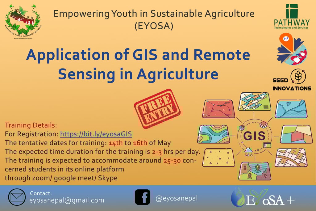
Online Training on Application of GIS and Remote Sensing in Agriculture
Empowering Youth In Sustainable Agriculture (EYoSA), in collaboration with Pathway Technologies & Services, Seed Innovation Nepal, and YouthMappers Puranchaur, is delighted to announce an upcoming Online Training on the Application of GIS and Remote Sensing in Agriculture. This training aims to empower participants with knowledge of how Geographic Information Systems (GIS) can be applied to enhance agricultural practices and productivity.
EVENTS AND WORKSHOPS
5/27/20202 min read
Why GIS and Remote Sensing in Agriculture?
Geographic Information Systems (GIS) are essential tools for understanding and managing agricultural resources. By using GIS, scientists and farmers can analyze geographic and geologic features of farmland, which helps in making better decisions about crop management. Remote sensing, combined with GIS, allows for the collection of data on precipitation, temperature, soil types, and crop conditions over time. These technologies are vital for:
Mapping and Analysis: Understanding and visualizing the distribution of agricultural resources and identifying areas that need improvement.
Climate Prediction: Monitoring weather patterns and predicting fluctuations in precipitation and temperature, which helps in planning farming activities.
Crop Yield Optimization: Evaluating crop output, soil health, and nutrition levels to optimize yield.
Precision Farming: Implementing precise agricultural practices to enhance productivity and sustainability.
Through this training, participants will learn to harness the power of GIS and remote sensing, which can lead to more effective and efficient farming techniques, ultimately boosting food production and sustainability.
Training Objectives:
By the end of the training, participants will:
Understand the core concepts of geospatial science and how they relate to agriculture.
Learn to install and navigate GIS software to carry out essential tasks.
Gain knowledge of GIS mapping, database management, and spatial analysis.
Develop skills in data visualization for presenting geographic information effectively.
Learn to integrate, analyze, manage, and present spatial data, focusing on agricultural practices.
Understand how GIS can be applied to monitor soil conditions, track crop growth, analyze weather patterns, and plan for efficient farming operations.
Key Topics Covered:
Introduction to Geospatial Concepts:
Basic understanding of geographic information systems.
Overview of remote sensing and its relevance to agriculture.
GIS Mapping:
Creating and interpreting maps for agricultural use.
Understanding geographic coordinates, layers, and spatial data.
Database Management and Spatial Analysis:
Managing geospatial databases for agricultural applications.
Analyzing spatial data to determine trends and make decisions.
Data Visualization:
Techniques to visualize spatial data for easy interpretation.
Software tools for effective data representation.
Practical Application of GIS in Agriculture:
Monitoring soil health and fertility.
Managing water resources and irrigation planning.
Crop yield assessment and planning.
Identifying suitable areas for specific crops.
Hands-on Software Training:
Step-by-step guide on installing and using GIS software.
Practical exercises on real-world agricultural data.
Training Details:
Fee: Free of cost (Certificate available for NRs. 100)
Who Should Attend:
Students, researchers, and professionals interested in GIS and its applications in agriculture.
Farmers and agricultural entrepreneurs looking to adopt modern farming techniques.
Anyone curious to learn how technology can revolutionize agriculture.
Registration Link: Register Here
Registration Deadline: 27th May 2020
Event Date: 30th May 2020
Mode: Online (Participants will receive the link upon registration)
Benefits of Attending:
Enhanced Skills: Gain hands-on experience in using GIS tools and techniques for agricultural applications.
Networking: Connect with experts, fellow participants, and stakeholders from various fields of agriculture and technology.
Certification: Obtain a certificate of participation for a nominal fee, validating your new skills in GIS and remote sensing.
Partners and Support:
This event is supported by:
Pathway Technologies & Services
Seed Innovation Nepal
YouthMappers Puranchaur
Empowering Youth In Sustainable Agriculture (EYoSA)
For More Information:
Visit Our Facebook Page: EYoSA Facebook
Email: eyosanepal@gmail.com
This online training is a unique opportunity to develop your skills in GIS and remote sensing, paving the way for smarter, more informed agricultural practices. We encourage everyone with a passion for technology and farming to register and join us on this learning journey.
Don’t miss out! Register today and be a part of the future of agriculture!
Empowering Youth In Sustainable Agriculture (EYoSA)
Donate us for Empowering more Ag Youth
Looking for Collaboration ?
Explore EYoSA resource material and Publication
© ® 2018 by Empowering Youth In Sustainable Agriculture (EYoSA). Design by Axile Pvt.Ltd.
Become a EYoSA member and get update with resource, program, events, published resource and innovation.
Build a strong network and connect with Next gen Agriculture Youth with Experts and Farmers
EYoSA Publications
Farmer Magazine
Innovation Lab
e-Library
Report
Assets
Partners
Projects
Programs
Events
Info-graphs
Crop-charts
Organization
About Us
Our Journey
FAQ
Contact Us
Organization
Career
Research Grants
Internship
Farmers Field Day